|
|

|
|
|
|
Lewis and Clark 101 Continued ...
Jefferson's private secretary was a man
named
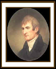
Meriwether Lewis, a Virginian frontiersman and soldier.
He had served in the army in Ohio with a former Army captain and
friend,
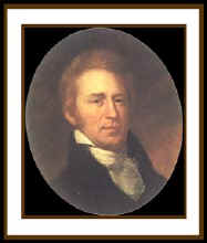
William Clark. These two men would work together as partners for
President Jefferson. The two were to share joint command as they
explored,
mapped, and studied a new route to the Pacific.
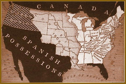
News of the Louisiana Purchase sped their
preparations for the journey
Eastern
Legacy MP3
Trip Map pdf
Lewis had copies of most of the available maps of the
northwest, which included those of Captain Vancouver and
Alexander Mackenzie. He had abundant supplies, equipment and
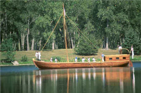
trading goods ready. Boat builders were adapting a
55 foot Keelboat, which could be sailed,
rowed, poled like a raft, or towed from the riverbank. In
addition to the Keelboat, two wooden row boats called
Pirogues were taken
to hold men and supplies.
Wintering at Camp Dubois
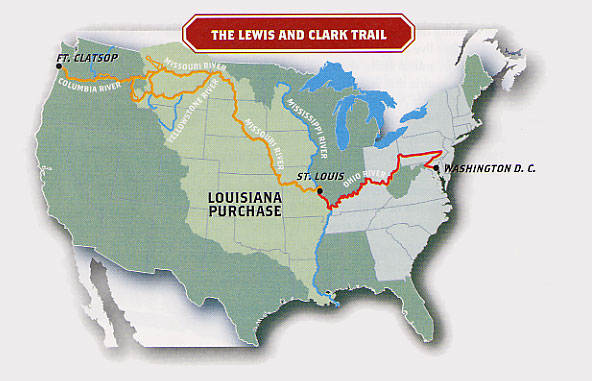
In late 1803,
Lewis and Clark took their men and their boats to
Camp DuBois to spend the winter at the mouth of the
Missouri. In the spring and after the formal transfer of
Louisiana to the United States, Lewis remained in
St. Louis
to attend to diplomatic business while Clark took the party
up river to
St. Charles.
Up the Missouri
The
Adventure Begins MP3
On May 21, 1804 "The Corps of Discovery" set out on one of
the most documented American adventures. By July,
the
Corps had
traveled into Indian country, but had not met up with any
Indians. Then, during a halt a
hunting
party met up with a Missouri Indian. A few days later a
company of
Otoe and Missouri came to visit. Lewis spoke to the
assemblage about the United States control of Louisiana and the
need for peace between Indians and Americans.
On the Great Plains
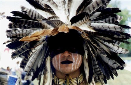
Lewis knew that he would soon run into the Sioux and they might
not receive him so cordially. Lewis finally made contact with
the
Yankton Sioux at Calumet Bluff on August 30th. He saw little of
the ferocity of the Sioux in this first meeting, and the expedition
parted from the Yanktons' on the best of terms.
For a while, the Corps spent some idyllic days hunting the
abundant autumn game, while Lewis was happily engrossed with natural
history. This mood was shattered by the keelboat's
approach to another Sioux camp, which turned out to be far from
peaceable. When Lewis tried to begin a council, the chiefs reacted
with suspicion and belligerence. The
Teton Sioux did not want a powerful force of white men so deep
within their country. But again the explorers? combination of
coolness and firepower kept the Indians from starting a fight. As a
result, peace had been preserved, and the Corps of Discovery sailed
on.
Winter at Fort Mandan
Because the weather had turned cold, windy, and wet, a winter
campsite was urgently needed. One was found near the
Mandan Villages in present day North Dakota by the time of the
first snow, and its construction was begun in November. A stout log
fort called
Fort Mandan was completed by December 24th, 1804, and
the Corps settled in for the winter. While at Fort Mandan, Lewis
made contact with fur traders, one of them was a French Trader
Touissant Charbonneau that was married to a
Shoshone girl named
Sacagawea, who would later be helpful to the
expedition. When spring freed the keelboat from river ice,
Lewis sent it back east with some of the soldiers
and many of the new discoveries. The narrowing river demanded
smaller craft, and so the Corps made six canoes to supplement the
two pirogues.
Into the Real Unknown
On
April 7th, 1805, Lewis and Clark and the Corps of
Discovery headed west. By late April they had reached the junction with
the
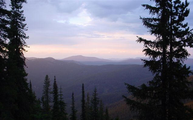
Yellowstone River, which was located in the rugged foothill country.
This region held some animals which were strange to them, mountain
sheep, mule deer, and
grizzly bears.
While bears were keeping the hunters busy, the Missouri was
occupying the river men. They began a grueling portage around the 90
foot cascades of the
Great Falls. The men made a crude wagon to carry the boats and
supplies around the falls. They had to repair the wagon constantly, but
finally in mid-July, the 18-mile detour was over, and the Corps went
back on the river to force their way up into the Rocky Mountains.
The Northwest Passage
Lewis and Clark had been shocked to find that the Rockies were
not a single wall of mountains. They still believed that the
Columbia headwaters would be waiting for them after a short
overland trek across the Continental or Great Divide. By July 25th,
they had reached another expected landmark, the
Missouri's Three Forks. Lewis and a few men
left the party to forge ahead on land and look for the Shoshoni.
They roamed the river valley for days while Clark and the others
dragged the boats up the stream. Lewis knew the need for Indian
help grew even more desperate. Without horses the "Corps of
Discovery" would not be able to continue. The day after crossing
the Divide, Lewis met a band of Shoshoni and sent for Clark and
the rest of the company. When they arrived, it was discovered
that the leader of the Shoshoni band was
Sacagawea's brother. This family connection
helped the Corps acquired horses, information and a guide. They
cached
their canoes and some equipment on the newly named
Jefferson River, and then struggled off on heavily laden horses
over underbrush choked mountain trails looking for navigable
water. In
September, they decided to turn north to the Bitterroot
Valley in order to strike an
Indian trail
described by the Shoshoni. The trail was rocky and
horses crippled themselves and some even fell off the slopes.
The hunting was poor and the men hungry. They soon found before
them lower, less rugged terrain, and a creek which they were
sure would lead to the Columbia River. A headlong descent by the
starving, weakened men brought them to a hospitable
Nez Perce camp, where the Indians fed them with dried
salmon. Here the weather was warmer and the game more plentiful.
After they had been fed and had rested, the Corps began to
travel again. Within a few days they had reached the Clearwater
River, a tributary of the Snake which led to the Columbia.
Descending the Columbia
On
October 16th, almost without
warning the men found themselves on the broad waters of the
Columbia, rushing toward the Pacific Ocean. When they
reached the
Narrows of the Columbia, Lewis saw the water "boiling
and whirling in every direction" over jagged rocks, but the
impatient Corps flung their canoes through the obstacles,
without any damaging effects. A longer portage had to be
made around the ferocious waters of the
Cascades. By early November the Cascades were behind
them; they had overcome the last mountain obstacle and were
moving through tidewater.
Ocean in View ~ O' the Joy!
Within a few days, the river widened into a broad bay.
The Corps thought (mistakenly) that they could see the
Pacific. Clark wrote
"Ocian in view! O, the joy!", but that
joy turned to misery when rough water and torrential rain
drove them to camp under the bay?s sheer cliffs. After a few
days they paddled into the Columbia's estuary, with the open
sea spread before them. Later while a spot for a
winter camp was being
voted on, Clark carved on a
tree: "William Clark, By land from the U. States
in 1804 and 1805."
Departing Fort Clatsop
Leaving
Fort Clatsop, Oregon on March 23,
1806, the Corps of Discovery began their journey home.
Having survived a winter of sickness, monotonous diet,
and dreary weather, the impatient explorers departed
after gifting Fort Clatsop to a
Clatsop leader. It had been
almost two years since they had left Wood River,
Illinois in May of 1804. The explorers were
backtracking across familiar terrain and their previous
route, however they would alter their path after passing
the
great falls of the Columbia.
Trading canoes for horses the explorers continued their
journey by land to the
Walla Walla (Walula) Indians.
Camping among the tribe for two days, Chief Yelleppit
informed them of an overland shortcut to the Nez Perce.
This route took the party across present towns of
Waitsburg, Dayton, and Pomeroy,
Washington.
Reaching the Snake River on May 4, they
continued traveling up the north side of the river
before settling into a camp on May 14, awaiting the
snows to melt in the Bitterroot Mountains. Their
campsite was called "Camp Chopunnish",
a word Lewis used for the Nez Perce, located near
Kamiah, Idaho.
On
June 10,
they gathered their horses and proceeded
on to Weippe Prairie. Four days later Lewis
reported in his journal, "we have now been detained near
five weeks in consequence of the snows; a serious loss
of time at this delightfull season for traveling. Every
body seems anxious to be in motion." The next
morning they departed Weippe Prairie in an attempt to
cross
Lolo Trail. On June 17 the
disappointed explorers returned to the Prairie and hired
an Indian guide from their nearby campsite of
"Chopunnish". On June 24 the party set out
along with their three Nez Perce guides arriving at
Traveler's Rest (near present
Missoula, Montana) six days later.
On July 3, 1806, the Corps of Discovery left
Travelers' Rest.
Captain Lewis and nine men went to pursue a direct
route to the Missouri, then explore Maria's river.
Captain Clark and the rest of the party went a new
route to the Jefferson River, then descended to the
Three Forks and then proceeded with a detachment party
to explore the Yellowstone, while Sergeant Ordway, with
nine men, descended the Missouri.
Map of Routes
Reuniting on August 12, at
Reunion Bay near New Town, North Dakota,
days later Lewis and Clark bid farewell to
Sacagawea,
paid Toussaint Charbonneau for his services and turned
their canoes south, arriving in
St. Louis 37 days later.
|
|
|