Travel the Lewis and Clark Trail !


 Lewis and Clark Trail "Re-live the Adventure"

Follow Us on Twitter  Become a Fan on Facebook

PODCAST

Directory

Search the Trail

Travel the Trail 
Lewis and Clark and the Indian Country National Traveling Exhibit.  Click and learn more >>
Lewis and Clark
Public Art
Photo Gallery
Escorted Tours
Discover the Rivers of Lewis and Clark
Travel Stories
Travel the Trail ~ From Sea to Shining Sea
Travel Planner
Events & Exhibits
Eastern Legacy Trail
Lewis & Clark in Kentucky
Lewis & Clark in Indiana
Lewis & Clark in Illinois
Lewis & Clark in Missouri
Lewis & Clark in Kansas
Lewis & Clark in Iowa
Lewis & Clark in Nebraska
Lewis & Clark in
South Dakota
Lewis & Clark in
North Dakota
Lewis & Clark in Montana
Lewis & Clark in Idaho
Lewis & Clark in Oregon
Lewis & Clark in Washington 
Print & Play Travel Games (PDF)>>

South Dakota

DID YOU KNOW?  Dakota is an Indian Name.   Learn More >>

Click on a number to visit the historical site, or the city for more info.
Includes: Historic Sites in Northeast Nebraska
Click on a number to visit the historical site.
Click on the city for more details on the area.

Explore South Dakota Outdoors

Native American Scenic Byway

Heritage and Culture

SD Cultural Heritage Center, Pierre, SD - South Dakota's Largest Museum/Cultural Center
605-773-3458
Lewis & Clark in South Dakota Online Exhibit

Download Maps

Lewis and Clark Map  73kb PDF

"Lewis & Clark on the Great Plains Timeline" 720 kb   PDF 
Missouri National Recreational River  1014 kb PDF

Lewis and Clark were instructed
by President Jefferson to:

A. Map a new route to the Pacific Ocean
B. Make contact with the Native Americans
C. Obtain specimens for further study
D. Keep a full record of activities during the Expedition

Whether you're planning a weekend getaway or a week-long vacation, LewisandClarkTrail.com is your online connection for Hotel Reservations.   Still planning your trip? Check out the events calendar,  read travel stories, then finish planning your trip by booking your hotel.  LewisandClarkTrail.com invites you to locate the Hotel  that meet your travel needs.  Thank you & travel safely.

History
From the Journals of
Lewis and Clark
Lewis & Clark 101
Lewis & Clark Biography 
Thomas Jefferson & Louisiana Purchase
Corps of Discovery
Lewis & Clark with Sacagawea
Lewis & Clark Among the Tribes
York, Clark's man-servant
Seaman, Lewis' Dog
Clark as Cartographer
Lewis as Botanist
Medical Aspects
Courts Martial
Geology on the Lewis and Clark Trail
Lewis and Clark 1804 Timeline
Lewis and Clark 1805 Timeline
Lewis and Clark 1806
Trail Trivia

 For Educators

Teaching & Lesson Plans
(MHS)

Learning Page
(Library of Congress)

Beyond Lewis & Clark (KSHS)


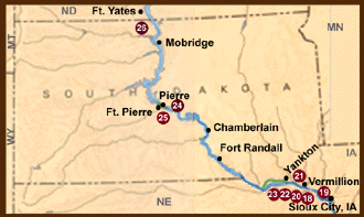
18. Ponca State Park - Interpretive sign and trail.

Back to Top

19. Missouri National Recreational River - A 59-mile segment from Ponca State Park to Gavins Point Dam that still exhibits the conditions encountered by the Expedition.

Back to Top

20. Ionia Volcano - On August 24, 1804, Clark recorded: "Those bluffs appear to have been lately on fire." Access permitted by private landowner. Interpretive sign in Newcastle city park.

Back to Top

21. Spirit Mound - On August 25, 1804, Lewis and Clark walked to this conical hill which the Indians believed to be the residence of "little people or Spirits." Interpretive sign along State Route 19 about 7 miles north of Vermillion.

Back to Top

22. Calumet Bluff - The Expedition’s council with the Yankton Sioux at this site is interpreted nearby at Gavins Point Dam Visitor Center and at Lewis and Clark State Recreation Area, South Dakota

Back to Top

23. Gavins Point Dam Visitor Center - Lewis and Clark interpretation Center (Yankton, SD).

Back to Top

24. Farm Island State Recreation Area - Visitor center; Lewis and Clark monument and interpretive shelter.
GPS Coordinates : 44° 20.25 N    -   100° 16. 45 W

Back to Top

25. Teton Council Site - Lewis and Clark held a council with the Teton Sioux on September 25, 1804, at the mouth of the Bad River. Later in the day and again 2 days later, hostile actions of the Teton warriors created confrontations that nearly came to armed conflict.

Back to Top

26. Site of Fort Manuel - Location of Missouri Fur Company post where Sacagawea died December 20, 1812. No public access. Interpretive sign on bluff along State Route 1806 south of Kenel.
GPS Coordinates:  45° 30.97 N  -   100° 29.26 W

Back to Top

See North Dakota for more sites.


IT'S NEVER TOO LATE TO THINK ABOUT THE FUTURE


Are interested in receiving a tuition scholarship?
Army ROTC may be
right for you.
 
Learn more >>


LewisAndClarkTrail.com LLC

Maps on this web site were provided courtesy of the National Park Service
GPO 1991-557-779


Copyright 1998, LewisAndClarkTrail.com - all rights reserved. LewisAndClarkTrail.com and "Re-live the Adventure" are trademarks. Reproduction of any part of this web site, for any use, is prohibited without prior approval of LewisAndClarkTrail.com.


 Explore, enjoy and protect the planet.