|
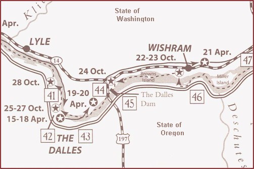 41.
Columbia Gorge Discovery Center: Includes the Wasco
Country Historical Museum. Lewis & Clark Exhibits
and outdoor trail.
42. Rock Fort Campsite: The Corps
established a defensive position here on both the outbound and return
journeys. Interpretive signs.
43. Dalles Murals: At several
locations in the downtown area, large murals depict Lewis & Clark's
arrival and the Indian trading center at Celilo.
More >>
44. Horsethief
Lake State Park: Here the Corps camped after running the
"Narrows" and visited an Indian village where Clark counted 20 wooden
houses.
45. The Dalles Dam: This area was the
center of trade for tribes from the Plains to the Pacific. Visitor
Center and guided tour train.
More >>
46.Celilo Park: The Corps portaged around
these great falls, now under water. Interpretive signs.
47. Maryhill
Museum of Art: Exhibits include Indian baskets and stone
tools. Overlooks Columbia River.
Map Source: Lewis & Clark
Bicentennial in Oregon 1200 SW Park, Portland, OR
97205. Ted Kaye & Roger Cooke.
|