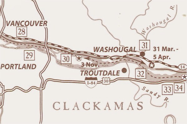 
28.
Vancouver National Historic Reserve: The replica of Hudson's
Bay Company's Fort Vancouver overlooks the area of the Corps' campsite,
whose exact location is uncertain. Visitor center and interpretive
signs.
29. Portland International Airport: The Corps twice
visited Neerchokioo bvillage, a temporary residence for Shahala Indians
when gathering wappato-the site is now under airport parking lots.
No interpretation.
30. Government Island: Lewis & Clark called this "Dimond
Isl" for its shape, and camped on its north shore. Access by
boat only.
31. Parker's Landing: Camping at the mouth of the
Washougal for six days. the Corps traded with the Indians and hunted elk
for the return trip. Interpretive sign.
32. Lewis & Clark State Recreation Site: The
Corps' hunters explored this area at the mouth of the Sandy River, which
they called the "Quicksand". Sergeant Pryor ascended six
miles. Interpretive signs and botanical trail; historical museum
in Troutdale.
33. Vista House/Crown Point State Park: The original
"comfort station" on the Historic Columbia River Highway
commands a 30 mile view of the Columbia River Gorge National Scenic Area
and several Lewis & Clark sites. Interpretive exhibits/signs.
34. Rooster Rock State Park: Clark wrote " we
encamped under a high projecting rock on the Larboard Side"-
Interpretive signs. Map Source: Lewis & Clark Bicentennial in
Oregon 1200 SW Park, Portland, OR 97205. Ted Kaye
& Roger Cooke.
|