|
Lost Trail Pass |
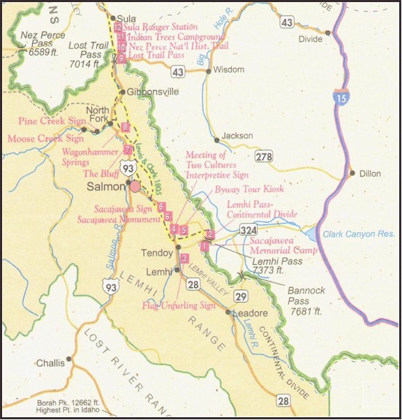
Lost Trail Pass
#9 on Map
September 3, 1805After traveling for a time in what is now Idaho, the
explorers again entered Montana very near Lost Trail Pass.
An
interpretive sign at the pass explains all of the historical trails in
the area.
If you come across Lemhi Pass, take ID 28 to US 93
North.
If you have taken the paved road route 278, go
Northwest on MT 43 to reach Lost Trail Pass.
|
|
|
WELCOME TO LOST TRAIL
PASS # 9 |
Historical Sites to see in the area.
-
Sacajawea Memorial Camp: Located east of
the Lewis and Clark Back Country Byway in Montana. Interpretive
signs & a wildflower interpretive trail.
-
Lemhi Pass-Continental Divide: Mile 26 of the
Back Country Byway, rough trailhead & interpretive signs.
Lewis crossed this point on August 12, 1805.
-
3.Flag Unfurling Sign: Mile 115.8 of Hwy
28 near Tendoy. Tendoy is the entrance to Agency Creek Road,
which leads to Lemhi Pass. Dirt road is steep and narrow,
generally impassable all winter. Call ahead to find out
current conditions, BLM (208) 756-5400.
-
Meeting of Two Cultures: Approx. 0.4 on
Alkali Flat Road, which is at mile 4.1 on Back Country Byway.
Sign & hiking activities.
-
Back Country Byway Tour Kiosk
-
Sacajawea Signs: Monument, mile 120.5,
Hwy 28; Famed Interpreter sign, mile 122.5 Hwy 28. Signs
celebrating the birthplace of Sacajawea, the Lemhi Shoshoni woman
who accompanied the Expedition.
 Sacajawea Interpretive Center - Salmon, Idaho
-
The Bluff: Interpretive sign. On August
21, 1805, Clark and party reached the Salmon River and camped near
this spot by the bluff near the mouth of Tower Creek.
-
Wagonhammer Springs: Mile 324 US Hwy 93
Lewis and Clark trail can be reached by walking 2 miles up West
Wagonhammer Creek to Thompson Gulch, follow marked trail on left.
-
Lost Trail Pass: Elevation 7,014 feet.
Visitor's Center is open during summer at Idaho-Montana border.
-
Nez Perce National Historic Trail: Mile 7
US Hwy 93 South, follows the route taken by the Nez Perce during the
War of 1877, and is an opportunity to hike the area where Clark
traveled. An of-highway section is accessed from Hwy 93 south
of Indian Trees Campground.
-
Indian Trees Campground: Near mile 8 on
US Hwy 93, 1 mile SW on Forest Road 729. In the Bitterroot
Valley and surrounding mountains, scars are often visible on the
trunks of centuries-old Ponderosa pine trees. Salish,
Kootenai, Nez Perce and Shoshoni Tribes stripped pieces of outer
bark to obtain the tree's sweet cambium layer for food.
Culturally scarred trees are federally protected.
-
Sula Ranger Station: Mile 11 US Hwy 93
South. The ranger station is just south of the "Great
Clearing" (Ross's Hole), site of the Salish village where the
Expedition spent two nights. Clark camped nearby on his return
trip in July 1806.
Map Source: Idaho Travel Council
|
|
|
|
|